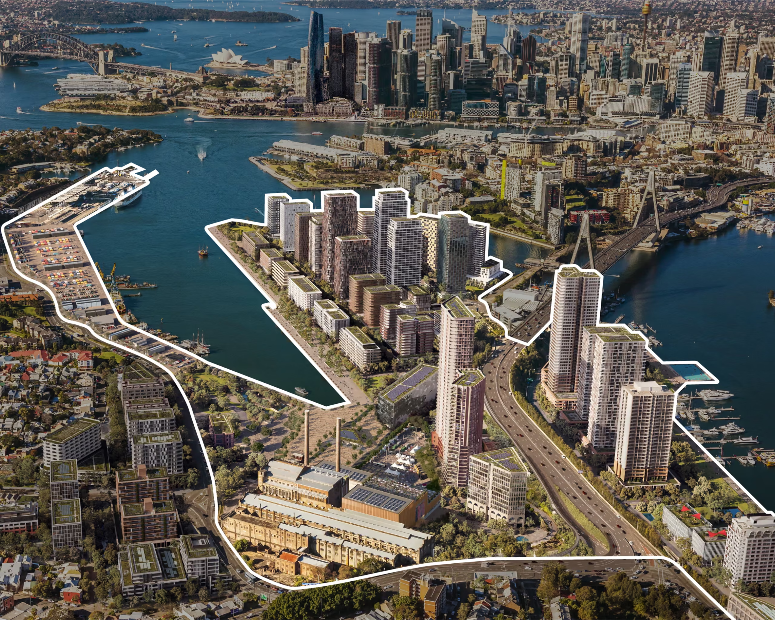
Glebe Island, the no-man’s land between Balmain, Rozelle, Glebe and Pyrmont is officially slated for redevelopment. The NSW government made an announcement last week and I thought I’d have a look at it to understand how our chosen home in Sydney will transform over the coming years once we’re long gone from here.
We have lived in Balmain for the last four years, and I have documented some aspects of our life on this blog already, such as a walk along Darling Street, thinking about the suburb’s remarkable economic history, or pondering Callan Park and NIMBYism. I once dwelled on post-political planning processes and how they can create gargantuan infrastructure projects like the Rozelle Interchange.
The Glebe Island redevelopment ties in with all of the posts above. The ramifications will be felt across Balmain, not least because of a new metro station and new zoning ordnances reaching deep into the suburb. The area’s strong working harbour heritage will continue to erode, although that is probably not a bad thing given the state of the waterfront near Roberts Street. Callan Park activists will look closely whether redevelopment here will take pressure off the Park or pile more onto it. The local infrastructure challenge will only grow, possibly making the daily commute across Anzac Bridge even more tedious.
The redevelopment will see the largest working part of Sydney Harbour shutter by 2030, with the cement works relocated outside the city’s boundaries, and some of the port infrastructure also moving elsewhere. The cruise ship terminal will remain, much to the chagrin of residents here given the slow adaptation of shore power for the mooring ships. See the Guardian coverage here.
The state government has made some aerial model impressions available which I pasted above, and we can see quite nicely the scale of the proposed redevelopment. About 8,500 homes / apartment units will be created, 10% of which are earmarked to be affordable. Some of the residential towers are likely going to be 40 stories high.
The White Bay Power Station is going to remain a cultural hub, while the planned metro station will link the area seamlessly to the center. Zoning ordnances around this new station will also be relaxed, likely resulting in further higher rise developments just outside the proposed area, as can be seen on the Balmain side already. Incidentally, this is very close to our former apartment, whose vicinity will not be recognizable in a few years time if the above comes closer to fruition.
The land is leased to developers under a similar deal as the much-maligned Barangaroo redevelopment. Critics contend that this is likely to create the same logic of extraction here than in the city center as well as elsewhere in the city (and the world, that is).
As under this deal, Glebe Island will remain in public hands, it allows the state government to not apply its pre-election pledge to earmark 30% of new housing to be affordable. Affordable housing is of course also not the same as social housing, which will not be created in this redevelopment anyway. Barangaroo affordable housing occupants reportedly have to use separate entrances and have no access to shared facilities like gyms and pools.
The big question coming out of this for us critics is how one can mobilize large sums of capital to build at scale new homes to overcome the housing crisis, and to create healthier inner-city residential density levels. The prevailing answer in Sydney and elsewhere that this will best be shouldered by the private sector has accelerated house price inflation and built enclaves for the rich.
I find it hard to swallow that the externalities of a metro station and a world-class cultural center hosting an art biennale and parts of the annual Vivid festival will mainly accrue to those able to pay for the apartments in this area. I doubt that projects like this represent “density done well” or are an answer to the question of how to limit westward sprawl.
